![]()
NEW YORK, NY, UNITED STATES, June 25, 2026 /EINPresswire.com/ —
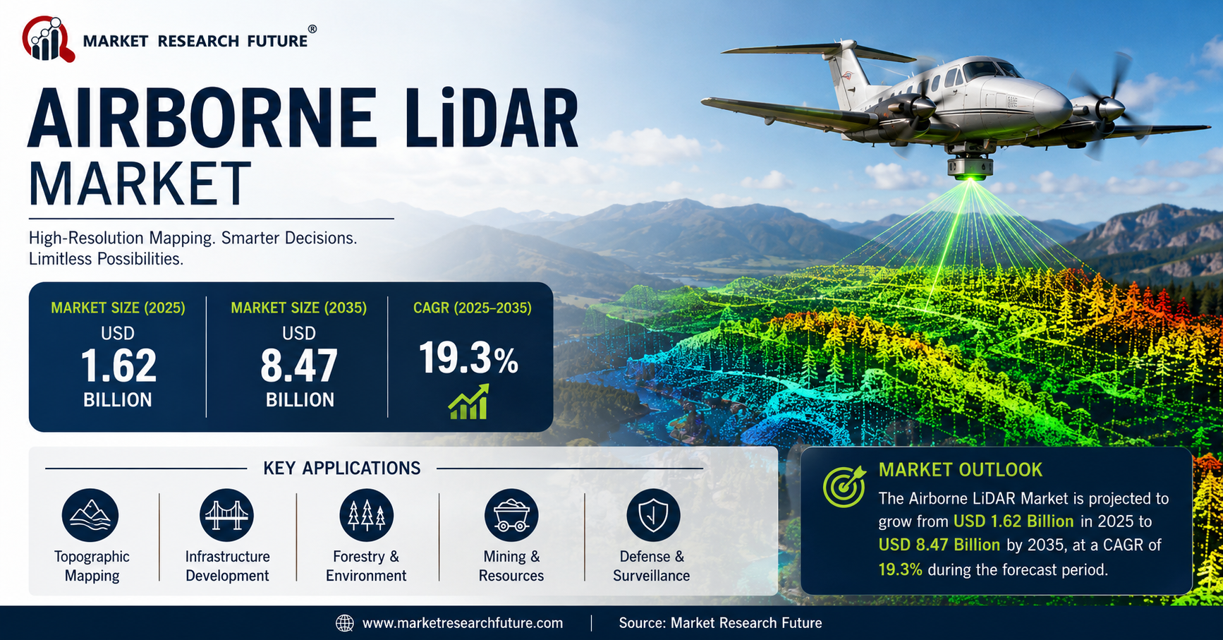
The global Airborne LiDAR Market is witnessing remarkable growth as governments, infrastructure developers, environmental agencies, and defense organizations increasingly adopt advanced geospatial technologies for precise terrain mapping and data collection. According to Market Research Future, the Airborne LiDAR Market was valued at USD 1.62 billion in 2025 and is projected to grow from USD 1.73 billion in 2026 to USD 8.47 billion by 2035, registering a strong CAGR of 19.3% during the forecast period from 2025 to 2035. The growing demand for high-resolution topographic mapping, smart city development, digital elevation models, environmental monitoring, and corridor mapping is accelerating market expansion worldwide.
Market Overview
Airborne LiDAR (Light Detection and Ranging) has emerged as one of the most reliable remote sensing technologies for acquiring highly accurate three-dimensional information about the earth’s surface. Mounted on aircraft, helicopters, and drones, LiDAR systems emit laser pulses toward the ground and measure the reflected signals to create detailed terrain and object models.
The technology has transformed the way governments and enterprises conduct surveying, urban planning, forestry assessments, mining operations, disaster management, and infrastructure inspections. Airborne LiDAR offers superior accuracy, rapid data acquisition, and the ability to penetrate vegetation cover, making it an indispensable tool for modern geospatial intelligence.
The market’s strong growth trajectory is supported by rising investments in national mapping initiatives, transportation infrastructure modernization, environmental conservation programs, and defense surveillance projects. The increasing adoption of digital twins and smart infrastructure planning is further strengthening demand for airborne LiDAR solutions.
Request Sample PDF of Report: https://www.marketresearchfuture.com/sample_request/6016
Latest Trends Shaping the Airborne LiDAR Market:
1. Integration of LiDAR with Digital Twin Technologies
One of the most influential trends transforming the Airborne LiDAR Market is the growing deployment of digital twin platforms. Governments and enterprises are leveraging airborne LiDAR-generated datasets to build highly detailed digital representations of cities, transportation networks, industrial facilities, and critical infrastructure.
Digital twins enable planners and engineers to simulate real-world conditions, monitor infrastructure performance, and optimize maintenance activities. The requirement for precise geospatial information is driving demand for advanced airborne LiDAR surveys across developed and emerging economies.
2. Expansion of Drone-Based LiDAR Mapping
The increasing utilization of unmanned aerial vehicles (UAVs) equipped with LiDAR sensors is reshaping aerial surveying operations. UAV-based LiDAR systems provide cost-effective and flexible solutions for surveying remote, hazardous, or difficult-to-access locations.
Drone-based airborne LiDAR applications are rapidly expanding in agriculture, forestry, mining, utility inspections, and environmental monitoring, significantly increasing market opportunities.
3. Advancements in Sensor Technology
The development of single-photon and Geiger-mode LiDAR technologies has enhanced data acquisition capabilities while reducing operational costs. These innovations enable faster scanning speeds, greater area coverage, and improved accuracy.
Modern airborne LiDAR systems are capable of collecting billions of data points in a single mission, enabling organizations to generate detailed terrain models more efficiently than ever before.
4. AI and Machine Learning Integration
Artificial intelligence and machine learning algorithms are increasingly being integrated into LiDAR data processing workflows. These technologies automate point-cloud classification, object detection, terrain analysis, and feature extraction.
The use of AI significantly reduces processing times and enhances the value of airborne LiDAR datasets, supporting faster decision-making across various industries.
5. Growing Adoption for Climate and Environmental Monitoring
Governments and environmental agencies are increasingly using airborne LiDAR to monitor coastal erosion, flood risks, forest biomass, and ecosystem changes. The growing emphasis on climate resilience and sustainable development is creating substantial demand for high-precision environmental mapping solutions.
Key Market Drivers:
1. Rising Government Investments in National Mapping Programs
Government-funded geospatial initiatives remain one of the strongest growth drivers for the Airborne LiDAR Market. Many countries are investing heavily in creating high-resolution digital elevation models and nationwide terrain databases to support infrastructure development, disaster preparedness, and environmental management.
These long-term mapping programs provide consistent demand for airborne LiDAR services and hardware solutions.
2. Growing Infrastructure Development Activities
Rapid urbanization and infrastructure modernization projects across the globe are driving the need for precise surveying and mapping technologies. Airborne LiDAR enables accurate planning and monitoring of highways, railways, airports, bridges, and utility corridors.
As governments prioritize transportation and smart city initiatives, airborne LiDAR adoption continues to accelerate.
3. Increasing Demand from Forestry and Agriculture
Forestry organizations increasingly rely on airborne LiDAR to measure canopy heights, estimate biomass, monitor forest health, and support sustainable resource management.
Similarly, precision agriculture applications use LiDAR-derived terrain information to optimize irrigation, crop management, and land-use planning, creating significant market opportunities.
4. Expansion of Mining Activities
Mining companies use airborne LiDAR for exploration, resource estimation, pit monitoring, and environmental compliance. The technology’s ability to generate detailed topographic information significantly improves operational efficiency and safety.
The growing global demand for minerals and critical raw materials is expected to boost airborne LiDAR deployments within the mining sector.
5. Defense and Security Applications
Defense organizations increasingly utilize airborne LiDAR for surveillance, reconnaissance, terrain analysis, mission planning, and border monitoring. The growing emphasis on national security and defense modernization programs continues to generate strong demand for advanced airborne sensing technologies.
Emerging Opportunities:
1. Smart City Development Projects
The rapid expansion of smart city initiatives worldwide presents substantial opportunities for airborne LiDAR providers. Detailed 3D city models generated through LiDAR support urban planning, infrastructure optimization, traffic management, and public safety programs.
As governments continue investing in smart urban ecosystems, demand for airborne LiDAR mapping services is expected to rise significantly.
2. Coastal and Marine Mapping
The increasing adoption of bathymetric LiDAR for coastal surveying and underwater mapping creates attractive growth opportunities. Governments are investing in shoreline monitoring, flood mitigation, marine habitat assessments, and port development projects.
These initiatives are expected to drive substantial growth in bathymetric LiDAR deployments during the forecast period.
3. Renewable Energy Infrastructure
Renewable energy projects require highly accurate terrain assessments for site selection, construction planning, and operational management. Airborne LiDAR is increasingly used in wind farm, solar park, and hydroelectric infrastructure development.
The global transition toward clean energy is expected to generate new revenue streams for airborne LiDAR service providers.
4. Utility Corridor Management
Electricity transmission networks, pipelines, and telecommunications infrastructure require continuous monitoring and maintenance. Airborne LiDAR enables efficient corridor mapping and vegetation management, helping utilities improve reliability and reduce operational risks.
Growing investments in energy infrastructure modernization are creating long-term market opportunities.
Segment Analysis:
1. By Type
Topographic LiDAR – Topographic LiDAR represents the largest segment of the Airborne LiDAR Market, accounting for approximately 68% of total market revenue. The segment’s dominance is attributed to extensive use in terrain mapping, infrastructure planning, forestry management, and urban development.
Governments and engineering firms increasingly rely on topographic LiDAR to generate accurate digital elevation models and support construction projects.
Bathymetric LiDAR – Bathymetric LiDAR is expected to witness rapid growth throughout the forecast period, expanding at a CAGR of approximately 22.1%. The technology is increasingly used for coastal mapping, underwater terrain analysis, environmental monitoring, and maritime security applications.
Growing concerns regarding coastal resilience and climate adaptation are accelerating investments in bathymetric surveying technologies.
2. By Offering
Hardware – The hardware segment dominates the market with an estimated 61% share. Growth is driven by rising demand for advanced laser scanners, navigation systems, positioning technologies, and onboard processing units.
Continuous sensor innovations and fleet modernization initiatives among aerial survey operators are supporting hardware segment expansion.
Services – The services segment is expected to experience strong growth as organizations increasingly outsource data acquisition, processing, and analytics activities. The segment is projected to reach approximately USD 3.58 billion by 2035.
Many end users prefer managed LiDAR services due to lower operational complexity and reduced capital expenditure requirements.
3. By End-User Vertical
Aerospace & Defense – Defense organizations remain significant users of airborne LiDAR technologies for intelligence gathering, surveillance, mission planning, and terrain mapping. Increasing defense modernization programs are supporting segment growth.
Mining – Mining companies use airborne LiDAR to improve exploration efficiency, monitor site operations, and ensure environmental compliance. The sector continues to adopt advanced geospatial technologies to enhance productivity.
Forestry & Precision Agriculture – This segment is benefiting from increasing adoption of data-driven resource management practices. Airborne LiDAR supports biomass estimation, forest inventory management, crop monitoring, and land-use planning.
Corridor Mapping – Utility companies and transportation authorities increasingly utilize airborne LiDAR for corridor inspections, vegetation management, and infrastructure maintenance.
Oil & Gas – The oil and gas industry employs airborne LiDAR for pipeline monitoring, route planning, and environmental assessments, contributing to market growth.
Regional Analysis:
Asia-Pacific – Asia-Pacific holds the largest share of the Airborne LiDAR Market, accounting for approximately 36% of global revenue. Rapid urbanization, infrastructure development, and large-scale mapping projects across China and India are driving regional growth.
The region’s expanding transportation networks, smart city initiatives, and environmental monitoring programs continue to create substantial opportunities for airborne LiDAR providers. China and India together contribute more than 55% of regional revenue, highlighting their strategic importance within the market.
North America – North America represents the fastest-growing regional market, recording a CAGR exceeding 21% during the forecast period. Growth is supported by government-funded mapping initiatives, utility corridor management projects, forestry applications, and defense modernization programs.
The region’s strong technological capabilities and significant investments in geospatial infrastructure position it as a key growth engine for the global market.
Europe – Europe accounts for approximately 27% of global market revenue. The region benefits from extensive investments in environmental monitoring, flood-risk assessment, transportation infrastructure, and sustainability initiatives. Cross-border geospatial projects and climate adaptation programs continue to strengthen demand for airborne LiDAR technologies throughout Europe.
South America – South America is experiencing growing adoption of airborne LiDAR technologies across mining, forestry, agriculture, and environmental conservation applications. Government investments in resource management and infrastructure development are supporting market expansion.
Middle East & Africa – The Middle East & Africa region is gradually emerging as an important market for airborne LiDAR solutions. Increasing infrastructure investments, smart city projects, and environmental monitoring initiatives are expected to drive future growth.
Top Company Profiles:
Leica Geosystems – Leica Geosystems remains a global leader in airborne LiDAR technology, offering advanced laser scanning solutions, geospatial software, and integrated surveying systems. The company continues to innovate in high-precision mapping and digital reality capture technologies.
Teledyne Optech – Teledyne Optech is recognized for its sophisticated airborne LiDAR systems designed for topographic mapping, bathymetric surveys, and environmental monitoring applications.
RIEGL Laser Measurement Systems – RIEGL specializes in high-performance airborne laser scanners and integrated remote sensing solutions. The company’s products are widely used across surveying, forestry, infrastructure, and scientific research sectors.
Trimble Inc. – Trimble delivers comprehensive geospatial and positioning technologies that support airborne mapping, construction planning, and infrastructure management activities worldwide.
Velodyne Lidar – Velodyne Lidar, now part of Ouster, continues to play a significant role in LiDAR innovation through advanced sensor technologies and high-resolution mapping capabilities.
Topcon Positioning Systems – Topcon provides integrated positioning, measurement, and geospatial solutions that support airborne surveying and infrastructure management applications.
YellowScan – YellowScan focuses on UAV-based LiDAR systems and software solutions, enabling efficient aerial data acquisition across forestry, mining, and environmental monitoring projects.
Aerometrex – Aerometrex delivers advanced aerial mapping, LiDAR surveying, and 3D modeling services, supporting infrastructure, urban planning, and engineering projects globally.
Recent Developments:
November 2023: Hexagon’s Leica Geosystems introduced the TerrainMapper-3, featuring an effective pulse rate of 4 MHz, significantly enhancing wide-area topographic LiDAR data acquisition capabilities. The new system established a higher standard for aerial mapping productivity by enabling faster and more efficient collection of high-density geospatial data.
March 2024: Teledyne Optech launched the CZMIL Nova bathymetric LiDAR system, incorporating real-time visualization of shallow-water 3D terrain point clouds during flight operations. This advancement improved coastal and nearshore survey efficiency, enabling operators to validate data quality instantly and optimize mission performance.
June 2024: RIEGL unveiled the VQ-1560 III-S dual-channel airborne laser scanner with integrated inertial navigation technology. The solution streamlined aerial survey workflows by reducing post-processing requirements and cutting data processing time by approximately 35%, enhancing overall operational efficiency for LiDAR mapping projects.
September 2024: The U.S. Geological Survey (USGS) awarded approximately USD 280 million in new contracts under its 3D Elevation Program (3DEP). The initiative covers nearly 420,000 square miles of Quality Level 1 (QL1) airborne mapping across 14 western U.S. states, reinforcing the growing demand for high-resolution elevation data and large-scale geospatial infrastructure projects.
January 2025: Trimble integrated data generated by its Harrier 68i airborne LiDAR sensor directly into Trimble Business Center, enabling a more automated workflow for forestry analysis. The enhancement simplified data processing, accelerated project delivery timelines, and improved productivity for forestry and environmental mapping applications.
Competitive Landscape:
The Airborne LiDAR Market remains highly competitive, characterized by continuous technological innovation, strategic collaborations, and investments in advanced sensor platforms. Market participants are focusing on enhancing data accuracy, reducing operational costs, and expanding software analytics capabilities.
Companies are increasingly investing in AI-powered data processing, cloud-based geospatial platforms, and UAV-integrated LiDAR solutions to strengthen their market positions. Partnerships between technology providers, survey firms, and government agencies are expected to further accelerate market growth.
Future Outlook:
The future of the Airborne LiDAR Market appears exceptionally promising as demand for high-resolution geospatial intelligence continues to expand across multiple industries. Increasing investments in infrastructure modernization, climate resilience initiatives, digital twin technologies, renewable energy projects, and smart city development will create sustained opportunities for market participants.
Browse More Reports:
Airborne SATCOM Market
https://www.marketresearchfuture.com/reports/airborne-satcom-market-10143
Airborne Optronic Market
https://www.marketresearchfuture.com/reports/airborne-optronic-market-28911
Airborne ISR Market
https://www.marketresearchfuture.com/reports/airborne-isr-market-1334
Sagar Kadam
Market Research Future
+ +1 628-258-0071
sales@marketresearchfuture.com
Visit us on social media:
LinkedIn
Facebook
YouTube
X
Legal Disclaimer:
EIN Presswire provides this news content “as is” without warranty of any kind. We do not accept any responsibility or liability
for the accuracy, content, images, videos, licenses, completeness, legality, or reliability of the information contained in this
article. If you have any complaints or copyright issues related to this article, kindly contact the author above.
![]()
Media gallery